MAPS
OF OLD LONDON
| I. | WYNGAERDE (IN THREE SECTIONS) |
| II. | AGAS |
| III. | SECTION OF AGAS |
| IV. | HOEFNAGEL |
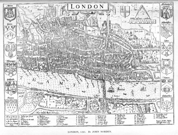
| V. | NORDEN LONDON |
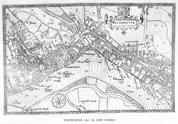
| VI. | NORDEN WESTMINSTER |
| VII. | FAITHORNE. |
| VIII. | OGILBY. |
| IX. | ROCQUE |
LONDON
ADAM AND CHARLES BLACK
1908
|
EDWARD STANFORD, Geographer to the King, 12, 13, and 14, Long Acre, London, W.C. |
EDITOR'S NOTE
An atlas of Old London maps, showing the growth of the City throughout successive centuries, is now issued for the first time. Up to a recent date the maps here represented had not been reproduced in any form, and the originals were beyond the reach of all but the few. The London Topographical Society has done admirable work in hunting out and publishing most of them; but these reproductions are, as nearly as possible, facsimiles of the originals as regards size, as well as everything else. It is not every one who can afford to belong to the society, or who wishes to handle the maps in large sheets. In the present form they are brought within such handy compass that they will form a useful reference-book even to those who already own the large-scale ones, and, to the many who do not, they will be invaluable.
NORDEN'S MAPS OF LONDON AND WESTMINSTER
Designer.—Being on a very small scale, these maps are not so attractive as some that have been already discussed. John Norden, the designer, was born about 1548, and seems to have had from the first an extraordinary gift of delicate penmanship, which he turned to much account in map-making. He projected a whole "Speculum Britanniæ," but during his lifetime only managed to publish books on two counties—namely, Middlesex and Hertfordshire. He left behind him the results of his labours on many other counties in manuscript, and these have since been published. Norden was appointed Surveyor of His Majesty's Woods in 1609. The engraving of the Middlesex maps was done by Peter Van den Keere.
Originals.—The reproductions are taken from those which appear in Norden's Middlesex, dated 1593. Each map is 9½ inches by 6¾ inches. The wonderful delicacy of Norden's work makes these maps peculiarly appreciated by students of London cartography.

